Development as disaster

Photo : Flickr / Feng Zhong
There are those who hope that human beings will learn from history. And there are others that know better. Then there are a few, like Sekar Harikrishnan, who do know better but are not prepared to let things be.
As a middle-aged fisherman, Sekar has lived long enough to see the dramatic transformation of the beaches near his native village of Injambakkam. The village is ten kilometres south of Chennai, off the East Coast Road that runs down Tamil Nadu's coast. When talking of his fast-urbanising village, Sekar is as moody as the horizon over a monsoon sea – remorseful one moment, angry another and resolute a minute later, as he speaks of how he intends to set things right. He has spent years fighting court battles to evict encroachers from the village's common lands, and developers who converted nearby water bodies into residential plots. His legal ventures to enforce manmade laws have not met with much success, but his faith in nature's law has shown more promise.
The 2004 Indian Ocean tsunami left over 11,000 people dead and displaced hundreds of thousands of people in India. "The tsunami hit them hard; serves them right. The sea went deep into and damaged every property that had come up on the sand dunes of the beach," Sekar says. The object of his ire was a line of opulent holiday homes built close to the shore.

Injambakkam, once considered the back-of-beyond for people in Chennai, is now rapidly urbanising. During Sekar's childhood, these lands were sprawling carpets of brown dunes that rolled westward. "As children, we'd tumble down the dunes for fun," he recalled. The more sheltered folds and watercourses on these hills were occupied by dune vegetation. Vegetation stabilises the sandy hills and makes them natural barriers against the seasonal tantrums of the sea. Moreover, these dunes serve as reservoirs of fresh water that prevent the seawater's subterranean advance into aquifers. By blocking salt-laden air and seawater from moving landward, dunes allow agriculture to flourish on their leeward side.
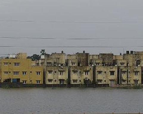
But the dunes are now gone. In August 2014, a friend and I walked along the beach from Thiruvanmiyur – once the southern end of the city – to Kovalam, 20 kilometres away. Nothing is left of the wild, empty spaces that once punctuated the stretches between these two fishing hamlets.
Not far from Sekar's village, a piece of beach that was golden sand just six months earlier, now sprouted a pucca asphalt road. Further down stood a glass-fronted building with a statue of the Buddha with its back to the sea. One property owner had enclosed a vast thicket of screwpine within a compound wall and topped it off with an electric fence. Nearby, a sprawling beach house sported a manicured lawn where there ought to have been sand. A sprinkler was throwing lazy arcs of water. Another Buddha, this one reclining, adorned the parapet surrounding a first-floor swimming pool.
Though Coastal Regulation Zone (CRZ) norms prohibit sinking borewells within 500 metres of the high-tide line since it accelerates salinity intrusion, each of these buildings has one or more borewells. Coastal Tamil Nadu's sandy beaches contain subsurface water flows that communities tap using hand-pumps and shallow wells. In many urbanised pockets like Injambakkam, groundwater is now salty because of the overdrawing of water. While the immediate damage of the tsunami is visible in terms of lives lost and damaged properties, the long-term damage to aquifers due to salinisation is not easily noticeable. After the 2004 tsunami, salinisation of near shoreline aquifers in most places, and inland aquifers in low-lying areas such as Nagapattinam, were reported. But as is evident in Sekar's village, activities that accelerate this process –flattening of dunes and sinking of borewells – go on without censure. If a tsunami or storm surge were to hit the coast today, salt water would penetrate far deeper and leave a longer-lasting effect on groundwater.
In Nagapattinam district further down south from Chennai, where coastal farming engages a sizable population, salinity of subsurface waters eroded the financial resilience of farmers by compromising their farm economies. Entire villages were robbed of their water independence and had to look for corporate handouts in the form of unviable desalination plants, or face long waits for government water schemes to reach them.
In 1991, the Government of India issued a CRZ notification to control development activities along the coast by prohibiting certain kinds of construction and regulating others. Over the next decade, however, exemptions were made for tourism projects, roads, the Department of Atomic Energy and residential buildings. Thereafter, the diluted law was further violated during the building of power plants, desalination plants, resorts, luxury homes, ports and roads along the coast. In a 2006 review of post-tsunami relief and reconstruction efforts, the Comptroller and Auditor General of India noted that violation of CRZ norms leading to overcrowding along coastal areas "played a major role in loss of human lives and property during the tsunami." It also noted that the "Ministry [of Environment and Forests] had amended the CRZ Notification and the range of amendments presented a trend that had allowed commercial and industrial expansion in coastal areas."
In the months after the tsunami, there was a new-found respect for the sea. Even the fisher-folk – no strangers to the fiery temperament of the sea – were petrified. Ironically, the decade following the tsunami has seen most rapid changes to Tamil Nadu's coastline.
This myopia has created a situation where even routine natural events have, and will become even more so, disasters and extreme events such as tsunamis or cyclones will now take a larger toll now than the previous tsunami. Moreover, contamination of groundwater with seawater, and the overall degradation of ecosystems and loss of traditional livelihoods over the years, will mean that affected communities will have more odds to overcome in the event of another disaster.
Fisherfolk and farmers
Natural events are not deemed disasters until human lives are affected, either by way of death and injury, or as loss of property or things valued by people. Any big disaster – be it 2005 Hurricane Katrina in the US, the 2015 Nepal earthquake or the 2004 Indian Ocean tsunami – is built on a foundation whose key ingredients include a poor understanding of how nature works and a deluded faith in the human and technological capabilities.
Like sand dunes on the beaches, the estuaries, tidal flats, mangroves, tanks as well as ponds in the coastal regions act as natural shock absorbers in the face of extreme events. Dunes, sandy beaches and mangroves attenuate cyclonic winds. Estuaries, mangroves and mud flats can absorb tidal waves and storm surges. Large water bodies like marshlands, tanks and ponds accumulate rainwater and prevent a heavy rainfall from becoming a flooding event. Apart from mitigating disasters, these structures also help in recharging groundwater.
The agriculture-rich coastal districts of Tiruvallur, Kanchipuram, Nagapattinam and Tirunelveli are dotted with ancient irrigation tanks called eris. These are tanks with crescent-shaped engineered bunds that hold water within a depression. Eris can be stand-alone, with their own catchments, or be a part of a network so that they receive the spillover from one or more eris, in addition to water from their own catchment. These are in addition to sprawling brackish water bodies like the Pulicat Lake, Ennore Creek, Pallikaranai marshlands, Kovalam and Muttukadu backwaters, the Odiyur lagoon and Mudaliyarkuppam estuary, the Kaliveli-Yedayanthittu estuary complex, Pichavaram mangroves, and the tidal mudflats of Vedaranyam and Kodikkarai.
Such structures in the coastal hinterland are integral with the coastal ecosystem, but neither planners, nor local communities, acknowledge their importance. For instance, fisherfolk seldom join the farmers to protest encroachment of an inland water body, and farmers are not found taking issue with activities that damage the beach.

Photo : Wikimedia Commons / Destination8infinity
Chennai's floods provide a case in point. Between 26 and 27 October 2005, the metropolis was crippled by floods following a 42 centimetre downpour for over 40 hours. Thirty-two people died and 50,000 people had to be evacuated from low-lying areas in the western and southwestern suburbs. The government blamed it all on 'unusually heavy rainfall'. Former Deputy Director General of Meteorology S Raghavan says planners, not the monsoons, are at fault. Reckless construction that blocks natural drainage courses and prevent rainwater from seeping into the ground is what caused the flooding, he says.
And the culprit is not just the impenetrable surface of the city, its roads, sidewalks, parking lots, which support surface runoff of rainwater rather than seepage. The Pallikaranai marshlands, which drain the eastern and southwestern suburbs of Chennai, now covers a tenth of the 6000 hectares it once sprawled across. Roads, a garbage dump, an IT corridor, a slum rehabilitation colony, elite gated-communities and engineering colleges have taken over the marshland, compromising its ability to withhold the monsoon shock.
Pallikaranai marshlands, classified as wastelands, as per Tamil Nadu's revenue classification, make it easier for the government to justify its diversion to pander to the urban demands for constructions. In Porur and Sriperumbudur to the west of Chennai, lake catchments – also identified as wastelands – have been parcelled off to telecom operators at Special Economic Zones and thriving but polluting automobile factories. With their inlet channels choked, even perennial lakes are drying up.
What we are seeing is a domino effect of development. Overdrawing of groundwater and the decline in recharging of aquifers have resulted in a drinking water crisis in the city. To solve this, expensive seawater desalination plants have been installed along the coast. One such installment, the 100 million litres per day Nemmeli plant, has caused widespread erosion of beaches in its vicinity and exposed the nearby fishing village of Sulerikattukuppam to the sea's wrath.
The desalination plants interfere with the routine expansion and contraction of the sandy beaches, and affect the quantity and direction of sediment that is transported by near-shore currents. In India's east coast, about 500,000 cubic metres of sediment on average drifts from south to north each year, nourishing beaches along the way. Any structure jutting out into the sea can block the sediment flow. This will starve the beaches immediately north of the structure of sand and over-nourish the southern beaches. Sulerikattukuppam had the misfortune of lying immediately north of a breakwater, jetty and a road built into the sea to bring in heavy equipment for the plant. Although the structure was ultimately removed from the surface, what remained beneath the sea continued to trap the silt and erode the beach in front of the village.
Without the beaches to protect them, the village was nearly destroyed by Cyclones Thane and Nilam in 2011 and 2012 respectively. Several community halls were swallowed by the sea. After a series of protests by the villagers, the offending structures were removed, and the beach is slowly returning to its original healthy state
City planners often overlook the connections between their actions and the damage caused by natural events. They argue that for the city to develop, empty wastelands and non-productive agricultural lands have to be sacrificed. But water will not stop falling or flowing just because the city needs to develop. It is ironic, for example, that the Pallikaranai marshlands, whose ability to absorb monsoon shocks has been severely compromised by infrastructure development, is also host to the National Institute of Ocean Technology, which offers advice on everything from climate change to marine engineering.
More of the same
The reason behind all of this myopia is probably the fact that beneficiaries of development and infrastructure do not share the burden of a disaster proportionally. The socially and economically marginalised rarely have a say regarding the intrusion of their habitat but have to bear the brunt of it anyway.
The 1800-megawatt North Chennai Thermal Power Station (NCTPS) is located on the northern bank of the Ennore river mouth, 25 kilometres north of Chennai. The plant is visible from the southern bank of the Ennore creek, from Sivanpadai Veethi Kuppam, a village of inland fishers. Signs of erstwhile prosperity can still be seen in this decaying village: a temple that was once well-adorned, neatly laid out streets. But of late, it has been coping with pollution, ill-health and dwindling catches. Environmental externalities of nearby industries, combined with the neglect of the state, has affected the livelihood of the fishermen. One should not have to ask how this once prosperous community will survive a natural disaster.
A thick film of oil covers the water, from the waste generated by the massive petrochemical refinery and associated plants in Manali industrial area nearby. At one end, a clutch of worn down huts stand. The huts are built on fly ash and surrounded by more of this toxic by-product of coal-fired electricity generation. The residents of the village are casual workers from the northern states of Odisha and Jharkhand.
A signboard on one such fly-ash-covered stretch of mudflats prominently declares that the 'land' belongs to the Ennore Port. The place was not land yet, but Ennore Port had a reason to be optimistic of its conversion from water to land because of the fly ash. The draft Coastal Zone Management Plan prepared by the Department of Environment identifies this patch of water as 'intertidal zone,' while the Chennai Metropolitan Development Authority's masterplan reserves it for an 'institutional area'.
Less than two years ago, this was a healthy ecosystem with water, life and livelihoods. Their vast surface area allowed them to swell and accommodate both rainwater runoff and tidal surges. Converting them into an institutional area will exacerbate flooding and deflect the impact of storm surges to less resilient areas.
Degradation of groundwater, the extinction of commercial fisheries and other factors that erode the self-sufficiency of communities also hurt their ability to recover after disasters.
Living in dangerous times
Inconsiderate use of land, especially along the coast, will be detrimental in the warmer years to come. The Intergovernmental Panel on Climate Change estimates that mean sea levels could rise by upto 44 centimetres by 2070. That will inundate low-lying areas, and bring the sea closer to existing coastal habitations. India's climate action plan already notes an increasing trend in severe storm incidence along the Indian coast.
A recent study by Chennai-based Centre for Development Finance assessed the economic impact of a one-metre sea level rise on Tamil Nadu's coast and reported that it would permanently flood 1091 square kilometres, and put six times as much land at risk. The replacement value of infrastructure such as ports, thermal plants and major roads could exceed INR 50,000 crores (USD 7.8 billion), while land at risk at 2010 market value could exceed INR 61 lakh crores (USD 950 billion). Ecosystems services foregone due to degraded wetlands would be anywhere between INR 3583 and INR 14,608 crore (between USD 560 million and USD 2.2 billion). However, Tamil Nadu does not seem keen to heed such warnings, even when Chennai's electricity and a fifth of its water comes from utilities set up on the coast.
There are no simple solutions to complex problems. The Indian judiciary follow the cue of the political class in talking of the need to 'balance environment and development'. This is a tiresome but predictable cliche. One has to be clear that the environment will not yield to the incorrigible ways of the elite driven human economy. If what you call development is not environmentally sensible, it will cause more harm than good – in the short and the long run.
~Nityanand Jayaraman is a Chennai-based writer and social activist.